Cerro Castillo, Chile, November 28, 2015
After a couple of weeks of
recharging, both mentally and physically, at my father’s house in Thunder Bay,
I returned to Leysin in late August. One
thing that didn’t recharge at all was the condition of my left leg, where
sciatic pain had only gotten worse, rather than improving. I had hoped that rest and relaxation would
let the problem heal itself, but this proved not to be the case. I woke up in the morning, or even in the
middle of the night, with my left hip so sore and tight that I could hardly get
out of bed. Hardly the best preparation
for six weeks of hiking in the Pyrenees and Corsica!
I had wanted to hike the Pyrenees
for many years, ever since my late uncle Piet told me stories of hiking the
length of the entire range back in the early 1990s. The Pyrenees sounded much less full of hikers
and climbers and cars than the Alps, and somewhat wilder. I realized that Terri and I didn’t have time
to walk the entire length, but the central part, from the Col de Pourtalet to
Andorra, looked like a doable three-week project. We bought Ton Joosten’s guidebook, The
Pyrenean Haute Route, and picked a segment of the route that looked like being the
right length and difficulty. I liked the
fact that Joosten’s route went back and forth across the Spanish-French
frontier, staying away from the lowlands and more-trafficked routes like the
GR10 and GR 11. Terri finally found out
about the date of her naturalization ceremony to become a Swiss citizen in
August, and we planned our trip around that.
We would hike for nineteen days from August 26th to September
13th, then Terri would fly back to Switzerland from Toulouse, I
would stay to do a few days of hiking, and then we would reunite in Nice on
September 16th to catch a ferry to Corsica to hike the GR20 for two
weeks.
It sounded like a good plan, and
we were excited as we took a day-long train trip from Leysin, via Lausanne,
Lyon and Montpellier, to the town of Pau.
We sat in the sun outside Lyon Port-Dieu train station while waiting for
a connection, eating sandwiches and soaking up rays, enjoying the sensation of
both of us being free (Terri had just finished her final term of teaching) and
talking about our upcoming hike.
 |
| Henri IV's palace in Pau |
We got
to Pau around 8:30 pm, put our heavy packs into our “apart-hotel” and scoured
the town for restaurants that were still open.
We found a great little Mexican restaurant run by two Sri Lankans (as
you do in a small city in France), then blundered into the sound and light show
at the old palace of Henry IV. We
learned a lot about the life and times of one of France’s more exceptional
kings, a Protestant king of a largely Catholic country racked by horrific inter-religious
strife oddly reminiscent of present-day Iraq or Syria. Pau looked like the sort of city that might
repay a bit more exploration one day.
The next morning, Wednesday
August 26th, we were up early and off to catch a bus. By 8:00 we were on a local bus to the Col de
Pourtalet, an absolute steal at two euros for a two-stage trip up the beautiful
Val d’Ossau that took almost two hours.
We missed our jumping-off point, and had to wait for the bus to turn
around at the top of the pass and start its return trip to get to our
trailhead. We hopped off, shouldered
packs and were off, heading steadily uphill up a green, beautiful valley. Looking back, we could see the steep grey
mass of the Pic du Midi d’Ossau rising behind us. The Pyrenean Haute Route stage we were
following started up near the summit in a mountain refuge, and by starting at
the road, we were saving over an hour, resulting in a day that was supposed to
be 6:45 in length, according to the Joostens guide. It was supposed to be challenging but doable
trekking, with spectacular scenery. We
were quite keen to get going and we stormed off uphill, through a pleasant
stretch of forest before the trail levelled off a bit to ascend a valley. We passed a shepherd’s hut surrounded by
sheep. As we continued climbing, we
looked back to see twenty or so griffon vultures circling in the sky, then
dropping down near the hut to feast on something dead, presumably a sheep. The Pyrenees are home to 90% of Europe’s
population of griffon vultures, the largest birds in Europe.
 |
| Terri heading off on our first morning |
Our route continued uphill to our
first pass, the Col d'Arrious at 2259 metres, some 900 metres above our
starting point. We sat and ate
sandwiches looking back towards the Val d’Ossau before advancing a bit to a
pretty lake where we had another snack and turned our attention to the first of
the “challenging sections” mentioned in the guidebook, the Passage
d’Orteig.
 |
| Reservoir near the Passage d'Orteig |
It looked frankly terrifying,
a traverse of a vertiginous cliff, equipped with chains. We set off, missing the path the first time,
and while it was uncomfortable at times because of our big packs, almost
borderline rock-climbing, it was far less impossible than it had looked from
afar. We breathed a sigh of relief once
we had struggled up the last steep section and looked down on the Refuge de
Arremoulit. It was easy walking down to
the refuge, built next to a pretty lake (the area was dotted with tiny lakes,
filling small depressions in the granite), and we treated ourselves to beer and
omelettes there. It was relatively late,
almost 4:00 pm, by the time we got going.
We weren’t too worried, as it was supposed to be about two and a half
hours to the next refuge and we had almost five hours of daylight left.
As it turned out, we should have
been worried. Our path led us around the
lake and then steeply up a tortured landscape of gigantic shattered
boulders. There was no path markers, and
finding the best way up was no easy task, as many of the boulders were loose
and threatened to tip sideways under our weight and send us sprawling. As we made our way up slowly, a pair of women
accompanied by a twelve-year-old boy appeared, coming downhill. They looked concerned that we were heading uphill
so late, although they told us that once we were over the pass, the path
markers would resume, making navigation simpler.
 |
| Path? We don't need no stinking path! |
This turned out to be a bit of an
untruth. We came over the top of the
pass, the Col de Palas (2517 m) and looked down into Spain, where a reservoir
sparkled blue against the shattered red and black rocky landscape. We found a few reassuring splashes of red and
white paint marking the way, and followed them diagonally downward to the left,
towards an immense rockslide. We could see
where the next pass, the Porte du Loveda (2600 m) must be, but it wasn’t clear
where the path would lead from the rockslide to the pass. As we picked our way painstakingly onto the
rockslide, we completely lost the paint markers. It took a lot of time to find a decent way
across, constantly searching in vain for the next marker. A lightly-laden trekker came up behind us,
moving quickly, and crossed the rockfall above us. We tried to follow his route, but it was
never clear that we were following a real path.
Across the rockslide, we walked approximately along the path of the
other hiker, now rapidly approaching the pass, and tried to keep him in sight
to get a feeling for the path.
It was slow going, and it took
forever to find the paint marks again.
We followed them upwards towards the Porte du Loveda, all the while
watching the other hiker bound uphill like a mountain goat and disappear out of
sight. He seemed to be following a
different route than that indicated by the paint markers, and so when we once
again lost the path, after searching in all directions for more markers, we
decided to follow the other man as he seemed to know where he was going. The climbing got more and more precipitous,
and eventually Terri decided that we must have made a wrong turn. I left my pack with her and went ahead to
scout. I found a way up to where the
other man had vanished from sight, but the descent on the other side was more
or less impossible without a rope, harness and bolts. On the bright side, though, I could see a
well-trodden path descending from further right along the ridge. I came back
down and we considered our options. I
thought we should retreat downhill to the lake to camp and try again in the
morning, but Terri was all for pushing on and getting to the hut.
We cast around again, rather like
Hash House Harriers, and finally came up with the paint flashes. They led uphill further to our right and we
followed, grateful to have found the right route. The route grew more and more vertical, to the
point where we were more or less rock-climbing with no rope and carrying huge
packs. While working my way up a
vertical chimney, the fuel bottle that I had attached to the outside of my pack
came loose and fell against a rock, breaking the fuel pump which was projecting
from the top of the bottle. This was a
major loss, as it meant that we could not cook.
We had other, more pressing concerns, though, as Terri was barely able
to get up the steep slope, even after passing her backpack up to me. Finally, though, with about an hour of
daylight left, we were across the pass and had only the downhill (an hour,
according to the book) between us and the refuge.
We set off downhill into French
territory again, following paint markings, and began traversing to our
right. Everything went well until we got
to another rockslide with no markers to be found. We cast around again and found nothing, but
the only practicable path seemed to lead downhill. It was a slow, hard descent requiring big
vertical drops on each step and treacherous footing on the loose rocks. All the time it was getting darker, and once
we realized that the ground in front of us was heading towards a cliff, we were
in trouble. At this point I was finally
able to convince Terri that we wouldn’t make it to the refuge, and that we had
to find someplace to bivouac. I scouted
ahead and found a small area that was less steep (I won’t say flat) where we
could spend the night. Terri was just
about done, and I had to do a few trips up and down a pretty steep fifty metres
of trail to shuttle our bags down.
 |
| Our tilted bivouac spot on the first night |
It was an uncomfortable night,
with both of us exhausted and yet worried about sliding downhill and over a
cliff in our sleep. We forced down a few
nuts and raisins, laid down our ground sheets and mattresses and fell
asleep. It was a majestic setting, with
a sky full of stars and the moon lighting up the massive rock ramparts on the
other side of our little valley. I awoke
a few times in the night from big gusts of wind, looked around to admire the
views, and fell asleep again. If we
weren’t lost and tired and worried about sliding downhill (which didn’t
happen), it would have been a perfect, memorable night.
In the morning, we ate a few nuts
and raisins, drank some water and began the tortuous ascent back up towards the
path. After 40 tough minutes, we were
back where we had lost the path previously.
We knew, from observations made as we climbed, that the real path had to
stay high and traverse to avoid the cliffs.
It took a lot of wandering in circles to find a distant cairn that led
to paint markers. It was still challenging
walking, but at least we knew we were on the right path again. We circled a long way to the right before
starting to descend through another valley that looked like the aftermath of a
giants’ rockfight. Inexplicably, we
chose to wander off the path again as two ascending hikers seemed to be
following a more direct route down to a large lake. Needless to say we got lost again when the
cairns ran out, but by now we were determined not to backtrack, and managed to
find a route to the lake, where we picked up paint markers again. It was still a good hour and a half of
walking to get to the hut, with several ups and downs to avoid cliffs, but now
we were back in well-trodden territory, and there were no major difficulties in
reaching the Refuge de Larribet, although it took us a total of three and a
half hours from our bivouac spot. The
timings in the Joosten book seemed to be highly optimistic, and (at least for
us) not a reliable guide to real time taken.
At the hut we demolished more
omelettes and beer, chatting to a local hiker, before starting the long trudge
down to the roadhead at Plan d’Aste. We
needed to find a place to replace the broken fuel pump, and we had also decided
that it was time to reassess our route plans.
It was a beautiful hike along a wide, easy path, past green forests and
burbling brooks, and by 4:15 we were at the end of the road, wondering how easy
it would be to hitch a lift down to Lourdes.
As it turned out, it was simple; the second car that went by picked us
up, bought us a beer in a local café, took us by a hiking shop in
Arzeles-Gazost (no luck with finding an MSR pump) and then went out of their
way to drop us in downtown Lourdes. We
ended up doing well with hitchhiking in the Pyrenees, which is just as well as
there is minimal public transport in a lot of the smaller valleys.
Lourdes was a surprisingly
rewarding spot to spend the night. I
knew very little about Lourdes except that the Virgin Mary was supposed to have
appeared there. I didn’t realize what a
huge tourism centre it is, rather like (in my friend Mark’s phrase) “Ibiza for
Catholics”. We found a cheapish hotel
(having hundreds of hotels brings competition), staggered there with our packs,
and then went out to explore. We passed
by the grotto where St. Bernadette had her visions in the mid-1800s. Thousands of votive candles were blazing in
dozens of stands outside, while wheelchairs carried those unable to walk and
hoping for a miracle. Food was plentiful and relatively cheap (11 euros for a
big steak with chips), catering to the pilgrims from every corner of the
world. We identified tourists from
Poland, Italy, Spain, Sri Lanka, India, Nigeria and Samoa, among many other
countries. After dark, we headed to the
huge church to watch the candlelit procession.
It was a really moving experience, even for a non-religious person like
me. The sheer number of pilgrims, the
heartfelt Ave Maria being sung en masse,
the hundreds of wheelchairs in the front rows, the thousands of candles
lighting up the square, made for a spectacle to equal Shwedagon Pagoda in
Yangon, the Barkhor in Lhasa, Mt. Kailash in Tibet or the Wailing Wall in
Jerusalem.
 |
| Candlelit procession in Lourdes |
The next morning, after sleeping
for 10 solid hours and waking up to aching muscles, backs and (in my case) my
left hip, we made use of the urban facilities available. We bought new maps and hiking guides, having
decided that the GR10 was more our speed.
I looked around, realized that MSR fuel pumps were thin on the ground,
and took to the internet to find a solution.
A French online shop, monrechaud.fr, had pumps in stock and would
deliver Poste Restante to any French post office. I bought the pump and had it shipped to Les
Cauterets, where we should arrive in three days’ time. I was glad to solve that problem, and we headed
out to have a picnic in the huge park across the river from the grotto. We wanted to restart our hiking from Arrens,
and there was no public transport leading there. We caught a bus in the late afternoon from
Lourdes to Arzeles-Gazost and then trudged a long way through town, trying to
find a spot to hitchhike. It wasn’t easy
to find a spot along a busy, narrow road leading to the Col d’Aubisque, but
eventually a thirty-something sawyer driving a cargo van stopped and drove us a
long way out of his way to deliver us to Arrens, another very positive hitching
experience. We found a beautiful
riverside campground and went out for delicious burgers in the village. That night was a full moon, and we watched it
rise over the mountains, with trees silhouetted against its face.
 |
| Full moon in Arrens seen through the trees |
We woke to a tent absolutely
soaking with dew. It was our first night
in the new ultralight three-man tent that Terri had recently bought, the Big
Agnes Copper Spur 3. Summer was
definitely thinking of leaving town, and there was an autumnal nip in the air
as we packed up the campsite. Leaving
Arrens, we felt as though we were re-launching our Pyrenees trip. The GR10, the long-distance path leading from
the Atlantic to the Mediterranean, was broad and well-marked, leading through
hardwood forests. Sadly a big landslide
had wiped out a section of the path, meaning that we had to backtrack, take a
detour and walk along a road for longer than I would have liked. Within an hour, we had crossed the Col des
Borderes (a lovely short cycling route that looked appealing) and were headed
back down into the adjacent valley and the village of Estaing. We dropped down to its pretty church and
headed upstream along a small river which made for a perfect picnic spot,
complete with ripe blackberries growing on the bank. We weren’t very far from the road that runs
up the valley, but traffic was light and the noise of the rushing water drowned
out most traffic sounds. We eventually
pulled away from the road and climbed up and down over a couple of small
ridges, startling a small snake, a toad and several lizards which were sunning
themselves on the path.
 |
| At Lac d'Estaing |
We sweated our
way up the final slope leading to Lac d’Estaing, where we had a well-earned
beer in a small restaurant and chatted with a couple of retired Cognac producers;
when we went to pay our bill, we discovered that the other couple had paid for
our beers. We walked for another half an
hour around Lac d’Estaing, a shallow body of water surrounded by steep
mountains on two sides and a gently sloping basin on the other two. Since it was a beautiful Saturday afternoon,
lots of daytrippers had driven up to the lake, but it didn’t feel too
crowded. We put up our tent in a small
campground and then wandered down to have a delicious (but expensive) meal at
the lakeside restaurant beside the campground.
After dinner we sat out beside the lake, watching the sunset, drinking
wine and feeling at peace with the world.
 |
| Lac d'Estaing makes Terri pensive |
We got up at 7:00 the next
morning, but only started walking at 9:40, a typically lazy start to our
day. My hip, which had been getting
sorer by the day, was almost completely seized up with sciatic pain the next
morning and I almost fell over as I tried to get out of the tent and stand
up. Luckily walking seemed to loosen
things up, so by the end of the day I was much more mobile (although I still
couldn’t swing my left leg with the knee straight, meaning that I had to limp
slightly throughout the day). We took
our time over a couple of coffees to give Terri her morning caffeine fix before
heading uphill along the GR10, climbing steeply uphill away from the lake. As we walked along, a few groups of mountain
bikers came racing past downhill. Just
as we left the forest and passed a shepherd’s hut, my beloved 18-200 mm camera
lens, which had been showing signs of not working optimally for a few weeks,
suddenly locked up completely, no longer zooming or focussing. I tried to coax it back into zooming, but my
efforts were rewarded by an audible crunch and the cessation of all
movement. After more than eight years of
work and many thousands of photos, the lens was no more. That left me with only my telephoto lens
working, which was great for wildlife and birds and details, but not for
landscape. My smartphone has a camera,
but it’s hardly the same thing as a digital SLR. Until I could replace it, my photography was
going to be severely curtailed, which didn’t make me very happy.
 |
| Terri storming up the Col d'Illheou |
We continued steaming ahead
toward the 2242-metre-high Col d’Illheou, until just below the top, when our
legs got a bit tired and we stopped for a picnic. The top of the pass was a beautiful grassy
meadow, full of well-tended horses, with steep rocky peaks looming above. Under a cloudless sky, the scenery was
perfect and I mourned the loss of my lens.
We meandered around on a long traverse to the Refuge d’Illheou, where we
had our obligatory omelettes and beers, before starting a very long trudge down
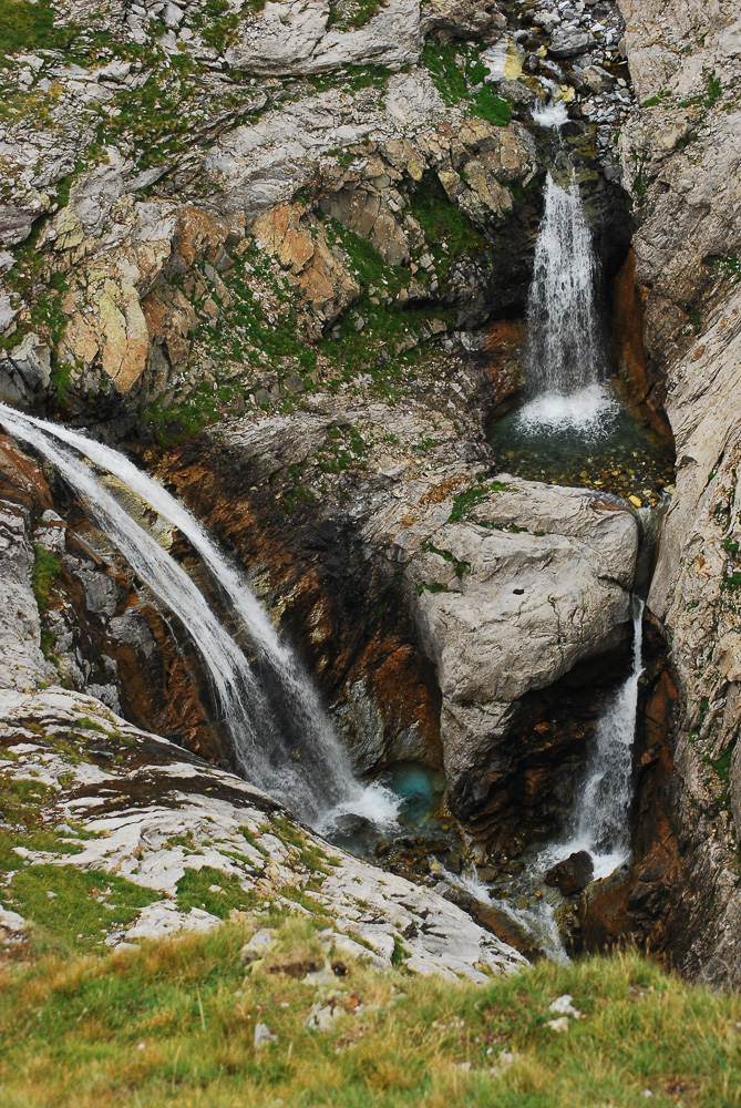
a steep-sided valley towards Les Cauterets.
A spectacular waterfall erupted into the valley partway down, and up
above we could see the lifts of a small ski area, Lys. We eventually passed the bottom of the lift
system, where more mountain bikers were barrelling down towards town. It was a surprisingly long descent into
Cauterets, down at 850 metres, and it took us a while longer to find a
campground. We put up our tent under
trees on lush grass and then went into town to find cheap eats; burgers and
fries and beers did the trick, and we wandered back to our well-earned sleep.
We took the next day off, as the
weather forecast called for severe storms.
Our first order of business was to pick up the fuel pump at the post
office. We wandered around the town, a
Belle Epoque spa town that now has an appealing atmosphere of slightly faded
gentility, then retreated to our campground with a roast chicken and salad
feast for lunch. Afterwards, I wrestled
with the stove; the new pump worked perfectly, but the methylated spirits I had
bought in the grocery store did not work as a fuel. A bit of internet searching on the smartphone
revealed that MSR stoves run on kerosene, gasoline or white fuel, but not
methylated spirits, so we eventually headed back into town and bought some
expensive white fuel. At 7 euros a
litre, it’s the cleanest and hottest-burning fuel, but at five times the price
of gasoline, I find it hard to justify buying it too often. I bought the fuel at a wonderful
mountaineering and trekking shop called Sherpa, run by a Nepalese guy; it
reminded me forcefully of the shops in Thamel where I have outfitted myself for
a few treks over the years. It began
raining as we walked back to the campground, and we huddled under an awning and
ate bread and pate and leftover chicken from lunch. It continued raining all night, sometimes
torrentially, not making for a restful night.
We began the next day lazily, not
even popping our heads out of the tent until 9, when the rain finally showed
signs of stopping. We celebrated having
a working stove by cooking up some bacon and eggs. Around noon we walked into town, where we
found we had a couple of hours to wait for the next bus up the road to Pont
d’Espagne. We stuck our thumbs out
instead, and quite quickly got a lift with a couple of sixty-something women
who crammed us and our backpacks into the back seat of a very small Renault for
the twenty-minute drive up a steep escarpment to the trailhead at Pont
d’Espagne.
 |
| Lac d'Aube |
We thanked them and then
headed off uphill through a wonderful Canadian Shield landscape of tumbling
streams, granite boulders and pine trees.
We reached a tiny lake, the Lac d’Aube, where we sampled the local
speciality, gateau Basque, before heading further uphill, through an enchanting
valley of amazing waterfalls, picturesque granite slabs and expansive views out
towards higher peaks. We stopped to
picnic on bacon and egg sandwiches in the midst of this idyllic area, then
continued climbing into the gathering mist until we reached the Refuge des
Oulettes de Gaube at 2150 metres. We put
up our tent, then wandered over to the refuge to escape the cold and damp and
have a beer. When we got back, the mist
had parted slightly and afforded us our first glimpse of the massive north face
of the Vignemale, the highest peak in the French Pyrenees at 3298 metres,
before the mist curtain closed again. As
we cooked dinner, we could hear the intimidating sound of a falling serac and
its attendant rockfall; it was too far away to affect us, but it sounded very,
very close indeed in the fog.
 |
| Vignemale |
We had a great night’s sleep, and
the next morning we didn’t start to stir until almost 8:00, as it was too cold
to want to get up before then. We cooked
pancakes, cleaned up and then started walking around 10:00. Our day’s stage was going to lead us over the
highest pass on the entire GR10, and Terri wanted to get over it before the
predicted bad weather appeared. We
climbed steeply up the valley wall, staring out at the Vignemale, now fully
visible under clear skies. We got to the
top of the Hourquette d’Ossons (2734 m) by 12:30, and then dropped down into a
greener but steeper world on the other side.
We descended to the Refuge de Baysellance for cake and a chat with two
young British university students. We
could look across towards Gavarnie and the dramatic peaks behind it, including
the well-known Breche de Rolland. They
dropped out of sight as we lost height quickly in a landscape of spectacular
waterfalls on all sides, some descending from the glaciers that cloaked the
south side of Vignemale. It seemed as
though every five minutes another high waterfall cascaded into view, splitting
a forbidding grey rock face with a glittering spout of water.
 |
| Waterfalls below Baysellance |
The slopes were alive with marmots, whistling
in alarm at our approach We eventually
got down to a dam, the Barrage d’Ossoue, and had another snack beside the water
before ambling further down the valley.
We traversed high above the river, cutting through big meadows grazed by
herds of cows, although the bucolic peace was shattered by a helicopter
shuttling construction materials to a tiny dam.
We passed the Cabane de Lourdes, marked on our map as a possible spot to
shelter, but it looked absolutely grim inside so we kept on going. The next little cabane, the Cabane de Sausse
Dessus, was much better, so we moved in, putting our air mattresses in one tiny
room and cooking in the kitchen. We knew
that storms were likely that evening, so sleeping indoors sounded like a good
idea. We had the place to ourselves, and
it was a lovely location, surrounded by cows and grassy meadows and steep rock
faces. We sat outside, sipping a
sundowner dram of whisky before moving inside to cook up miso soup, hash
browns, sausages and mushrooms, a veritable feast. It felt good to sleep under a solid roof that
night.
At about 3 am the heavens opened
in a Biblical downpour, accompanied by deafening thunderclaps and dazzling
lightning. It made us even more glad to
be indoors, although we didn’t sleep as well as we might have. The next morning we woke to find that the
rain had flooded down the chimney in the kitchen, soaking the floor; luckily we
hadn’t put anything important on the floor in the kitchen! We boiled up some oatmeal for breakfast
before setting off towards Gavarnie. It
took us longer than expected, two and a half hours, to get to Gavarnie, through
a landscape that would have been impressive if it hadn’t been wreathed in dense
fog. We arrived in town hoping to find a
computer to use to fill out an application form that we needed for our upcoming
Antarctic trip, and ended up in a café with wi-fi trying to type on our tiny
smartphone screens. As we nursed expensive
fries and beers, we caught up on e-mail, which brought important and unwelcome
news. Terri’s citizenship ceremony had
been changed from the 16th to the 30th of September,
which meant that we had to re-schedule everything in our trip. We had to leave the Pyrenees and head
straight to Corsica to do the GR20 before Terri flew back to Leysin, and that
meant we had just finished our Pyrenees walk after 7 days of walking, instead
of the planned 20 days. I was annoyed at
the Swiss government for being so disorganized, but Terri was more annoyed
since it cost her a small fortune in missed flights, new flights and missed
hotel reservations.
I loved the Pyrenees, even if our
time was drastically curtailed. I found
it wilder than most of the Alps, and not very busy with hikers. I would gladly come back to work my way east
from Gavarnie to Andorra or beyond, as I felt that no sooner had we gotten into
the rhythm of walking than we were torn away.
I also would love to base myself somewhere in the Pyrenees for a week or
two of road cycling on the classic passes like the Col de Tourmalet and the Col
d’Aubisque. Two thumbs up to the area,
and I hope to be back some day to see more dramatic landscapes!

No comments:
Post a Comment